Current research
Integrating deep-earth and surface processes for frontier-basin exploration


This industry-funded ARC project aims at investigating the interplay between plate kinematics, eustasy and mantle-driven topography in order to develop predictive models for frontier basin exploration.
Sea level has changed by up to 300m through geological time. These fluctuations, caused by plate tectonics and convection in the Earth's mantle, have created vast sedimentary basins and associated resources such as petroleum, natural gas and coal. In this project, we propose to bring together global 4D databases with cutting-edge 3D numerical simulations to reconstruct how mid-ocean ridge creation and the recycling of old, cold oceanic plates into the mantle have driven surface topography and sea-level change globally since the break-up of the super-continent Pangaea.
Linking lithosphere extension and plate kinematics
[under construction] Focus on the evolution of the South Atlantic and associated African and South American intraplate rift systems. Developed a new plate kinematic model for the evolution of the pre-breakup evolution of the South Atlantic rift.
Related content
- Paper: Heine and Brune, 2014, "Oblique rifting along the Equatorial Atlantic ocean: Why there is no Saharan Atlantic Ocean", GEOLOGY, DOI: 10.1130/G35082.1.
- Open access paper: Heine et al. "Kinematics of the South Atlantic Rift", 2013 Solid Earth, DOI:10.5194/se-4-215-2013. Initial submission available on arXiv.
- Supplementary plate tectonic reconstructions are available on the Datahub as well as with the Solid Earth paper: http://datahub.io/dataset/southatlanticrift.
GPlates-related research and development

I am involved with the development of the open-source plate tectonic modelling software GPlates, partly contributing to the implementation of lithosphere deformation in plate tectonic models as well as to the information architecture for the XML/GML-based GPlates Information Model (GPGIM), and GPlates Markup Language (GPML).
Related content
- GPlates Interoperability #1: Shapefile attribute standard for plate tectonic applications.
- GROT - The new GPlates rotation file format: GROT file format description for the new GPlates Rotation File format.
Links
Formation of sedimentary basins, plate kinematics and basin evolution
Broad intraplate basins often show a component of anomalous tectonic subsidence that is usually vaguely attributed to heterogenous basement ("accretionary crust") and which does not conform to the current understanding of rift basin evolution. In order to resolve the driving force and geodynamic framework for these long-term depositional regions, I am analysing a global set of more than 250 basins using various large scale geophysical data sets. The available crustal structure data is used to compute differential extension factor and quantify the amount of anomalous subsidence.
By integrating the crustal structure data into the EarthByte plate tectonic model and a global mantle convection framework I am able to analyse the long-term influence of dynamic topography on intra-continental basin evolution. So far, results indicate that most of the typical intracontinental basins experience a downward "mantle-drag" over the last 100 Ma, resulting in increasing negative dynamic topography and thus the creation of additional sediment accomodation space, which can not be detected with conventional basin modelling tools. Periods of basin inversion may also be linked to major changes in the dynamic topography gradient. This clearly indicates that the effects of mantle convection need to be considered in regional basin modelling studies.
Related publications
Links
- Basinatlas.com: The ICONS basin atlas webpages. These are also accessible through the EarthByte resource portal.
Completed projects
Plate kinematics, dynamic topography and Australian Palegeography
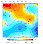
It is well documented that the Cenozoic progressive flooding of Australia, contemporaneous with a eustatic sea level fall, requires a downward tilting of the Australian Plate towards the SE Asian subduction system. We combine plate kinematics with a global mantle backward-advection model based on shear-wave mantle tomography, paleogeographic data, eustatic sea level estimates and basin stratigraphy to reconstruct the Australian flooding history for the last 70 Myrs on a continental scale. We compute time-dependent dynamic surface topography and continental inundation of a digital elevation model adjusted for sediment accumulation. The overall, long-wavelength spatio-temporal pattern of Australia's inundation record is well captured by combining our modelled dynamic topography with a recent eustatic sea level curve. Our model suggests that today's geography of Australia is strongly dependent on mantle forces. Without mantle convection, which draws Australia down by up to 300 m, nearly all of Australia's continental shelves would be exposed. We conclude that dissecting the interplay between eustasy and mantle-driven dynamic topography is critical for understanding hinterland uplift, basin subsidence, the formation and destruction of shallow epeiric seas and their facies distribution, but also for the evolution of petroleum systems.
Related publications
Links
- Data: Reconstructed topography as ArcGIS ASCII and GMT 4 netCDF grids. The data are released under a Creative Commons Attribution-Share-alike CC BY-SA) License.
- Animation: Reconstructed topography of Australia in response to dynamic topography (Quicktime, 9MB). This animation shows a modeled surface topography for Australia in 1 M.y. timesteps from 70 Ma to present - please read the paper for the technical details. Released under a Creative Commons Attribution-Share-alike CC BY-SA) License.
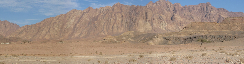
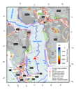
Geology of a large submerged continental block: The Kenn Plateau
(RV Southern Surveyor cruise 05/2004)
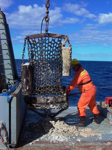
The Kenn Plateau region off northeast Australia in the northern Tasman Sea is a large submerged continental block that rifted off the eastern Australian margin during the opening of the Tasman Sea. The Southern Surveyor Cruise objective was to acquire geophysical and geological data from the Kenn Plateau to improve the understanding of the geological evolution and modern environmental setting of this poorly known area.
Related publications
Tectonic evolution of the Northwest Shelf of Australia
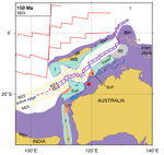
Magnetic anomalies preserved in the Argo and Gascoyne Abyssal Plains document a rifitng event on the Australian Gondwanaland margin in the late Jurassic, preceeding the India-Australia breakup. I have re-interpreted the magnetic anomalies off the Australian Northwest Shelf and derived a new plate tectonic model for the eastern Tethys and the Indian Ocean. This model explains the evolution of the Argo and Gascoyne Abyssal Plains, showing that the West Burma Block is the enigmatic Argo-Land. This work was my German Diploma-Thesis (Ruhr-Univ. Bochum; see link below for PDF).
Animation
- Quicktime Animation of the tectonic evolution of the eastern Tethys. Please use Heine, Müller & Gaina, AGU Geophys. Monogr. 149, 2004. as reference.
Related Publications
- Heine & Müller Aust. J. Earth Sci., 2005
- Heine, Müller & Gaina, AGU Geophys. Monogr. 149, 2004.
- PDF [9.8 Mb] of my Diplomarbeit/M.Sc. Thesis on the Tectonic evolution of the Northwest Shelf of Australia and southern Southeast Asia.